3D AIS Visualization
Use the Google Earth Network Link created by AIS Google Earth to display your AIS data in Google Earths 3D world.
Highlights:
- Near real time track updating
- Vessel are displayed and scaled according to what they transmit their length and width to be over AIS
- All Google Earths visualization features can be used to provide a detailed 3D AIS situation display for free!
- Use our S52 web rendering software to add real ENC/ECDIS charts op top of Google Earth
AIS Google Earth
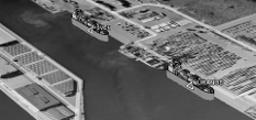
View your AIS data in 3D with vessels scaled according to
AIS information using Google Earth. AIS Google Earth integration converts
your AIS data stream into a Google Earth Network Link. This effectively
converts Google Earth into a high quality low cost (free) AIS Display
system. Vessels can be displayed as 3D models that are scaled according to
AIS information this allows for advanced 3D visualization of e.g vessel
incidents. To run AIS For Google Earth just press the launch button
below